The Piri Reis Maps are a collection of world maps that have baffled historians and scholars for centuries. These maps were drawn by the Ottoman-Turkish admiral and cartographer Piri Reis in the early 16th century.
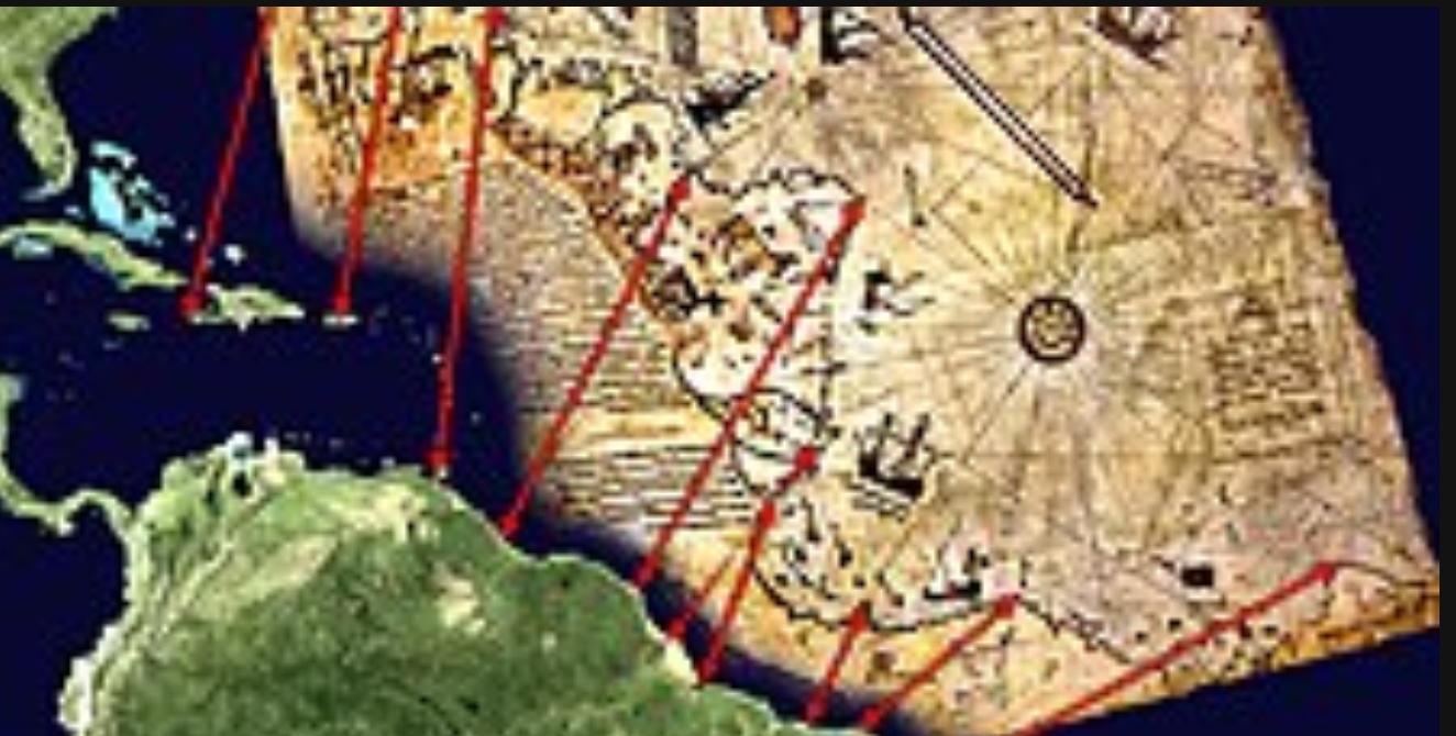
The most famous of these maps is the Piri Reis World Map, which was discovered in Istanbul in 1929. The map is notable for its depiction of the coasts of Africa, Europe, and South America, as well as parts of Antarctica.
While some believe that the Piri Reis Maps are simply the work of a skilled cartographer, others speculate that they may be evidence of advanced ancient civilizations or even extraterrestrial contact.
Read on to explore the theory that the Piri Reis Maps reveal alien contact with humans centuries ago.
Table of Contents:
I. The Piri Reis Maps: An Overview
II. The Controversy Surrounding the Piri Reis Maps
III. Ancient Astronaut Theory: The Possibility of Extraterrestrial Contact
IV. Evidence of Extraterrestrial Contact in the Piri Reis Maps
V. Conclusion: The Implications of Alien Contact
The Piri Reis Maps: An Overview
Maps have been an essential tool for humans for thousands of years. They help us navigate and understand the world around us. But what if a map could do more than just show us the lay of the land? What if a map could reveal secrets about our past, present, and even our future? This is precisely what some people believe about the Piri Reis maps.
Many researchers have studied the Piri Reis maps, and some believe that they contain evidence of an advanced civilization predating modern humans.
They point to the accurate depiction of the Antarctic coastline as proof that the ancient cartographers who created the map must have had access to advanced technology, such as aircraft or satellites. Others claim that the map contains information about a lost civilization, including its technology, culture, and even its location.
The Piri Reis maps are a collection of maps created by the Ottoman-Turkish cartographer Piri Reis in 1513. The maps are known for their incredible accuracy, particularly in regards to the coastline of South America and the Antarctic region. They were rediscovered in 1929 in the Topkapi Palace in Istanbul, Turkey, and have been the subject of much controversy and speculation ever since.
According to UNESCO The Piri Reis World Map of 1513 was discovered in the Topkapı Palace Library in 1929. Piri Reis’s is a portolan-style world map created in a time when positioning recently discovered places was almost technically impossible. Piri Reis succeeded in producing a detailed and considerably accurate depiction of the coastline and islands of the newly discovered regions of the world and formed a circular map designed on a hypothetical center with rich variety in illustrations. Also this map represents the earliest cartographic record of Columbus’s oceanic voyages and is among the earliest works showing Terra Australis, and the first map to depict its unique fauna.

The Controversy Surrounding the Piri Reis Maps
The Piri Reis maps have been a subject of intense controversy for many years, particularly regarding their accuracy in depicting the coastline of Antarctica.
According to mainstream historical accounts, the discovery of Antarctica did not occur until the early 19th century, well over three hundred years after the maps were created.
This apparent anachronism has led to numerous theories and hypotheses regarding the origins of the maps and their creator’s knowledge of Antarctica’s existence.
Some have suggested that Piri Reis may have had access to ancient sources of knowledge or advanced technologies, while others have proposed that he may have been the beneficiary of a previously unknown voyage to Antarctica but there is no evidence to support this claim.
Some historians have suggested that the maps may have been based on earlier maps or drawings, but this theory has been largely debunked.
Still, others argue that the maps may be nothing more than a clever forgery or a misinterpretation of ancient cartographic traditions. Regardless of the ultimate explanation, the enigma of the Piri Reis maps remains one of the most fascinating and enduring mysteries of cartography and human history.
Ancient Astronaut Theory: The Possibility of Extraterrestrial Contact
The concept of ancient astronaut theory has gained momentum in recent years, particularly among those who believe that the Earth has been visited by extraterrestrial beings in the distant past, who shared with ancient civilizations their advanced knowledge and technology.
This notion is not a new one, and in fact, has its roots in ancient mythology and folklore. The idea that gods or other celestial beings came from the skies to bestow knowledge and wisdom upon human beings is one that has been present in various cultures around the world for millennia.
The ancient astronaut theory is a more modern iteration of this idea, which proposes that the visitors were not gods or supernatural beings, but rather extraterrestrial in nature. Proponents of this theory contend that the presence of extraterrestrial beings on Earth is supported by evidence found in various historical accounts and archaeological artifacts, such as the pyramids of Egypt or the Nazca Lines in Peru.
One particularly intriguing piece of evidence cited by supporters of the ancient astronaut theory is the Piri Reis maps. These maps, which as you have read, date back to the 16th century, are believed to have been based on much older, pre-existing maps that depicted the coastlines of the world with remarkable accuracy.
However, as noted earlier in this post, what makes these maps particularly fascinating is the depiction of the coastline of Antarctica, which was not discovered until much later in history, long after the maps were created.
The accuracy of the depiction of Antarctica on the Piri Reis maps has led many to conclude that the cartographer, Piri Reis, must have had access to advanced knowledge or technology that was not available at the time.
Proponents of the ancient astronaut theory suggest that this knowledge may have been imparted to Piri Reis by extraterrestrial beings, who may have visited Earth and shared their advanced knowledge with select individuals in ancient civilizations.
While the ancient astronaut theory remains controversial and is often dismissed by mainstream historians and scholars, it continues to captivate the imagination of many people around the world. The idea that we are not alone in the universe, and that our ancestors may have had contact with beings from other worlds, is a fascinating one that raises many questions about the origins of human civilization and the nature of our place in the cosmos.
Claims of Evidence of Extraterrestrial Contact in the Piri Reis Maps
There are several pieces of evidence that proponents of the ancient astronaut theory point to as evidence of extraterrestrial contact in the Piri Reis maps. One of the most compelling is the accuracy of the maps in depicting the coastline of South America. The maps show the correct longitude and latitude of many cities and landmarks, including the Amazon River.
Additionally, the maps depict what appears to be a landmass south of South America, which many believe is Antarctica. This landmass is depicted with an incredible degree of accuracy, including the shape of the coastline and the location of several bays and inlets.
Finally, there are several annotations on the maps that some believe suggest extraterrestrial involvement. For example, one annotation reads, “These lands were discovered by Columbus in the year 1492.” However, Columbus did not discover South America, and it is unclear why this annotation would be included on the maps.
Conclusion: The Implications of Alien Contact
The question of whether or not the Piri Reis maps are evidence of extraterrestrial contact is one that may never be definitively answered. However, even if we assume that the maps were created without extraterrestrial involvement, their accuracy and level of detail are still remarkable.
The existence of the Piri Reis maps raises important questions about the capabilities of ancient civilizations and the level of knowledge and technology they may have possessed. It also highlights the importance of continuing to explore and study the past to gain a better understanding of our history and the world around us.
Ultimately, whether or not the Piri Reis maps are evidence of extraterrestrial contact is a matter of interpretation. However, they have captured the imagination of people around the world and have inspired countless theories and debates. The study of history and the exploration of the unknown will continue to reveal new and exciting discoveries, and the Piri Reis maps will undoubtedly continue to be a source of fascination for generations to come.
Your journey into one of the biggest mysteries of the ancient world has just begun! Discover More Here:
The Piri Reis Map: A Conundrum of Ancient Cartography
The Reality and Myth of the Piri Reis Map of 1513
Piri Reis’ Map: A Map to Intrigue East and West Alike
Piri Reis Map – How Could a 16th Century Map Show Antarctica Without Ice?
Stay up to date: Click here for more news and videos
Discover more from Your Assignment Editor
Subscribe to get the latest posts sent to your email.